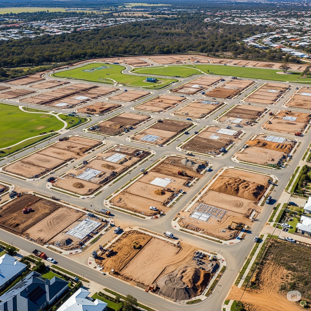
Western Australia’s landscape is one of constant transformation. From the sprawling new residential communities taking shape in the north and south corridors of Perth, to the critical infrastructure that supports our state’s economic powerhouses in the Pilbara and beyond, our growth is relentless. But this progress doesn’t happen by chance. Beneath every new road, every master-planned estate, and every major pipeline lies a foundation of meticulous planning, rigorous engineering, and precise documentation. This is the world of civil drafting.
For the project managers, civil engineers, and land developers steering these complex projects, civil drafting is far more than just “drawing lines.” It’s the technical language that translates geotechnical data, hydrological analysis, and engineering principles into a coherent, buildable, and compliant set of instructions. It is the discipline that shapes the very earth we build on, ensuring that our communities are safe, functional, and sustainable for generations to come.
Getting it wrong has significant consequences: crippling delays in approvals from authorities like the WAPC and local councils, budget blowouts from inaccurate earthworks calculations, and long-term asset failures due to flawed drainage or road design. Getting it right, however, means delivering a successful, profitable project that becomes a valued part of the community fabric. This guide is a deep dive into the essentials of civil drafting for land development and infrastructure in the unique context of Western Australia, designed for the professionals who are building our state’s future.
Section 1: The Scope of Civil Drafting: Shaping the World We Live In
Unlike architectural drafting, which focuses on vertical structures like buildings, or mechanical drafting, which details machinery, civil drafting is concerned with the “big picture” of the land and its infrastructure. It’s a broad discipline that encompasses the design and documentation of everything that connects our communities and makes them habitable.
In the context of a Western Australian project, a civil drafter is an essential integrator. They work at the nexus of multiple professions, taking raw data and complex designs and synthesising them into a unified plan. Their work involves:
- Data Integration: Taking topographic survey data, geotechnical reports, environmental assessments, and engineering calculations and combining them into a single, accurate digital model of the site.
- 3D Surface Modelling: Creating detailed 3D models of the existing landform and the proposed final design. This is fundamental for everything from calculating earthworks volumes to analysing water flow.
- Infrastructure Design & Detailing: Drafting the precise horizontal and vertical alignment of roads, designing stormwater drainage networks, laying out underground services, and detailing pavement structures.
- Compliance Documentation: Producing high-quality drawing sets that are specifically tailored to meet the stringent submission requirements of various WA government and utility authorities.
- Lifecycle Management: The drafter’s role doesn’t end when construction begins. They are often involved in providing construction support and, crucially, in preparing the final “As-Constructed” drawings, which become the official record of the newly built assets for the local council or utility provider.
A civil drafter on a WA land development project isn’t just sitting at a computer drawing lines; they are digitally sculpting the future community, ensuring every road has the correct grade, every house pad is safe from flooding, and all essential services are coordinated and correctly installed.
Section 2: The Land Development Lifecycle in WA: A Drafter’s Perspective
To truly understand the role of civil drafting, it’s helpful to walk through the typical lifecycle of a WA land development project, such as a new residential subdivision. An experienced drafting team is involved at every single stage.
Stage 1: Feasibility & Concept Design Before a developer even purchases a parcel of land, a preliminary investigation is done. A civil drafter may be engaged to create high-level concept plans based on aerial imagery and existing GIS data. This involves sketching potential lot layouts, road networks, and identifying major constraints like wetlands or significant vegetation. This initial work is crucial for determining the potential yield of the project and its overall financial viability.
Stage 2: Detailed Survey & Feature Integration Once the project proceeds, the first step is a detailed topographic survey of the site. A licensed surveyor captures the exact contours of the land and locates all existing features (trees, existing buildings, fences, etc.). This survey data, usually in a digital format, is provided to the civil drafter. Their first task is to process this data and build an accurate 3D model of the “existing surface,” which becomes the baseline for all future design work.
Stage 3: Engineering Design & Detailed Drafting This is the core of the drafter’s work, performed in close collaboration with the civil engineer.
- The engineer provides the design parameters (road widths, pipe sizes, pavement depths).
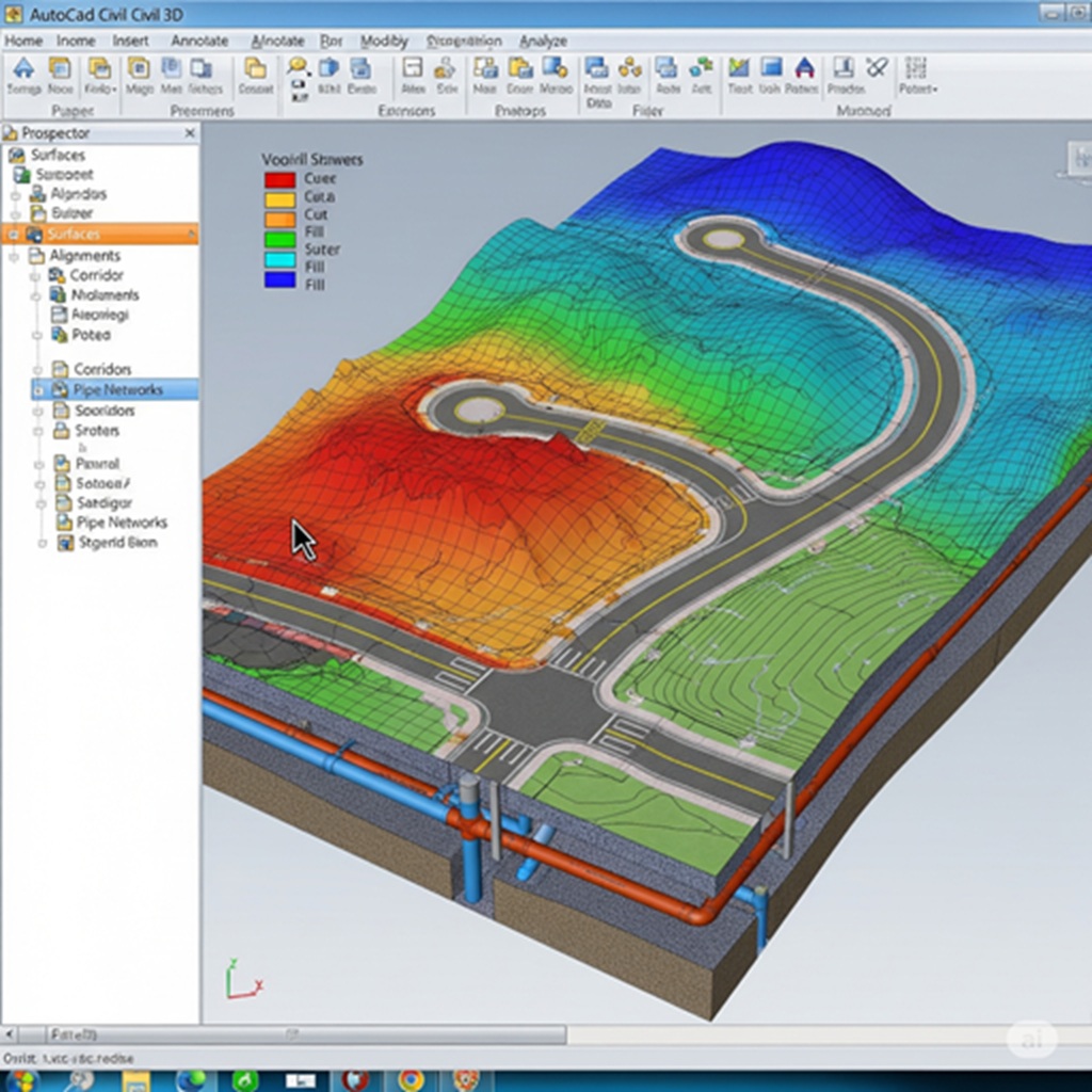
- The drafter uses powerful software like AutoCAD Civil 3D or 12d Model to execute the detailed design. They model the road corridors, grade the lots, design the stormwater pipe network, and lay out all other services. This is an iterative process, with constant refinement to balance costs (e.g., minimising earthworks) with technical requirements.
Stage 4: Submission for Approval The output from the design stage is a comprehensive set of “For Approval” drawings. In WA, these are submitted to multiple authorities, primarily the Western Australian Planning Commission (WAPC) for the overall subdivision plan and the respective Local Government Authority for the detailed engineering and civil works. The clarity, accuracy, and completeness of these drawings are critical for a timely approval. Incomplete or non-compliant drawings are a primary cause of project delays.
Stage 5: Construction Issue & As-Constructed Drawings Once approval is granted, the drawings are updated with any final conditions and issued “For Construction.” During the construction process, minor deviations can occur. The site surveyor records the final, exact location of all newly installed infrastructure (like pipes, pits, and road kerbs). This “As-Constructed” survey data is sent back to the drafter, who then updates the original design drawings to create a final, accurate record of what was built. This “As-Con” set is a critical legal and asset management document required by the local council and other authorities before they will accept ownership of the new public infrastructure.
Section 3: Core Components of a Civil Drafting Package for WA Projects
A professional civil drafting package for a land development or infrastructure project in WA is a complex set of documents. Each component requires specialised knowledge and meticulous attention to detail.
Earthworks & Site Grading
Before any construction can begin, the land must be shaped to its proposed design levels. This process, known as earthworks or grading, is one of an project’s most significant costs.
- Cut and Fill Calculations: The drafter uses the 3D models of the existing and proposed surfaces to calculate the precise volume of soil that needs to be “cut” from high areas and “filled” in low areas. The goal is to “balance the site,” meaning the volume of cut equals the volume of fill, which avoids the significant cost of importing or exporting soil. The drafter produces detailed volume reports and cut/fill maps that are essential for the construction contractor’s pricing and planning.
- Grading Plans: These drawings show the final proposed contours and spot levels for every part of the site, including individual house pads, roads, and public open spaces. The grading must ensure that all lots have positive drainage away from the building envelopes.
- Batter Slopes: For significant changes in elevation, sloping embankments or “batters” are designed. The drawings must specify the steepness of these slopes (e.g., 1 in 4, 1 in 6) to ensure they are stable and can be safely maintained.
Stormwater Drainage Design
In WA, managing stormwater is a critical design challenge, particularly on the sandy Perth coastal plain and in areas with high water tables. The goal is to manage runoff from roads and lots to prevent flooding and protect the downstream environment.
- Pit and Pipe Networks: The drafter designs the underground network of pipes and maintenance pits (manholes) that collect and convey stormwater. The drawings show the exact location, size, material, and invert levels (the internal base level) of every pipe and pit.
- Designing for ARI: The system is designed to handle a specific rainfall intensity, known as the Average Recurrence Interval (ARI). For example, the “minor system” (pipes) might be designed for a 1-in-5-year ARI, while the “major system” (overland flow paths like roads and swales) is designed to handle a major 1-in-100-year ARI event without flooding properties.
- Water Sensitive Urban Design (WSUD): Modern practice in WA focuses on WSUD. Instead of just piping all water away, designs often include bio-retention basins, infiltration swales, and soakwells that allow rainwater to soak back into the ground naturally. This is especially important for recharging groundwater on the Swan Coastal Plain and often involves designing systems to strip nutrients (like nitrogen and phosphorus) from the water before it enters sensitive wetlands or rivers. These features require careful detailing on the plans.
Roads & Pavement Design
The road network is the skeleton of any development. Civil drafting for roads involves detailing every aspect of their geometry and structure to ensure they are safe, durable, and comfortable to drive on.
- Horizontal & Vertical Alignment: The drafter details the horizontal layout (curves and straights) and the vertical profile (hills and valleys) of the road. This includes designing features like superelevation (banking) on curves to improve safety.
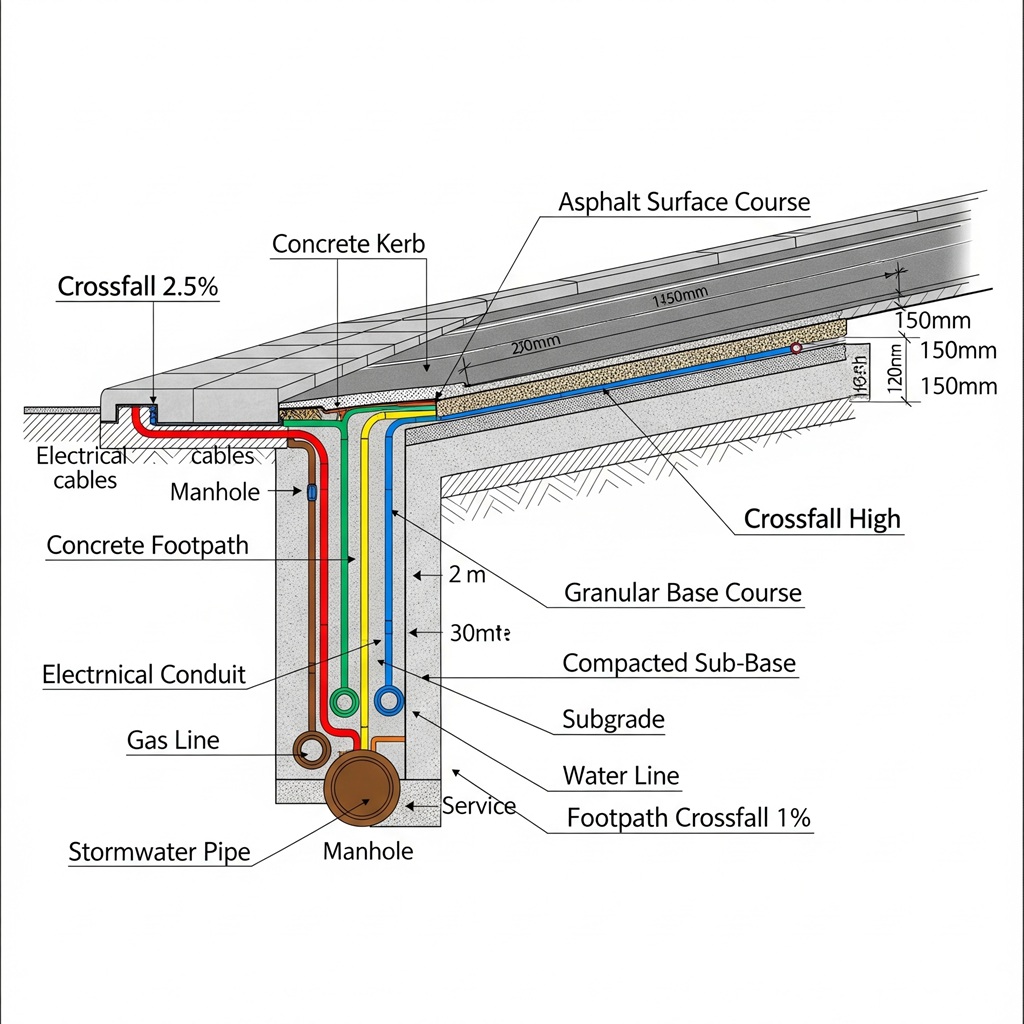
- Cross-Sections: Detailed cross-section drawings are produced every 10-20 metres along the road. They show a slice through the road, detailing its width, crossfall (the slope for drainage), kerb types (e.g., semi-mountable, barrier), footpath locations, and the location of the underground services corridor.
- Pavement Details: The drawings specify the thickness of each layer of the road pavement, typically including the asphalt wearing course, the roadbase, and the sub-base material. These details are based on the engineer’s design, which considers traffic loads and the underlying soil conditions, and must comply with Austroads guidelines and local council standards.
Underground Services Coordination
One of the most complex tasks in civil drafting is coordinating the “spaghetti” of underground services that run beneath our roads and footpaths. A clash between services on site can be incredibly costly to fix.
- Service Corridors: The drafter is responsible for allocating space for each utility within the road reserve. This includes water mains, sewer lines, stormwater drains, gas mains, electrical cables (high and low voltage), and communication conduits (e.g., NBN).
- Clearances: The drawings must ensure that the required vertical and horizontal clearances between different services are maintained, as specified by the relevant utility provider (e.g., Water Corporation, Western Power, ATCO Gas). For example, a water main cannot be laid too close to a sewer or high-voltage electrical cable. The drafter uses the 3D model to check for these clashes before construction.
Erosion and Sediment Control Plans (ESCP)
During construction, bare earth is exposed and is vulnerable to erosion by wind and rain. An ESCP is a mandatory part of the drawing set required by local councils to minimise environmental impact. The drafter prepares plans showing the location of temporary control measures like silt fences, sediment basins, sandbag check dams, and stabilised construction entry/exit points to prevent sediment from washing off the site and into the downstream drainage system or natural environment.
Section 4: The Toolkit: Software and Technology Shaping Modern Civil Drafting
The days of manual drafting with pen and paper are long gone. Today’s civil drafter is a highly skilled technology user, leveraging sophisticated software to create accurate and intelligent models.
- AutoCAD Civil 3D & 12d Model: These are the two dominant software platforms for civil design and drafting in Australia. They are far more than simple drawing tools. They are powerful engineering design applications that use a dynamic modelling approach. For example, if a drafter adjusts the vertical alignment of a road, the software automatically updates all the cross-sections, earthworks volumes, and surface models. This dynamic link between elements saves enormous amounts of time and drastically reduces the potential for human error.
- Geographic Information Systems (GIS): GIS platforms like ArcGIS or QGIS are used to manage and analyse large-scale spatial data. A drafter might use GIS to overlay the proposed development onto aerial photography, zoning maps, or environmental constraint data (like bushfire-prone areas or wetland boundaries) to inform the design.
- Drones (UAVs) and LiDAR: For data collection, traditional surveying is now often supplemented with aerial surveys from drones or aircraft equipped with LiDAR (Light Detection and Ranging). This technology can capture highly detailed and accurate topographic data over large areas quickly and efficiently, providing a rich dataset for the drafter to build their existing surface model.
- BIM for Infrastructure: The industry is moving towards a Building Information Modelling (BIM) approach for infrastructure. This means creating a highly intelligent 3D model that contains not just geometry, but also rich data about each asset (e.g., pipe material, installation date, manufacturer). This “digital twin” of the infrastructure is incredibly valuable for local councils for long-term asset management, maintenance planning, and future upgrades. A forward-thinking drafting team designs with this end use in mind.
Section 5: Navigating the WA Regulatory Maze: Compliance by Design
A technically perfect set of drawings is useless if it doesn’t meet the specific requirements of the numerous authorities that govern land development in Western Australia. A key part of a civil drafter’s role is to be an expert in navigating this complex regulatory landscape.
The key players include:
- Western Australian Planning Commission (WAPC): The primary authority for approving the subdivision of land. Their approval is based on compliance with state planning policies and the local planning scheme.
- Local Government Authorities (LGAs): The local city or shire council (e.g., City of Wanneroo, Shire of Serpentine-Jarrahdale) is responsible for approving the detailed engineering plans for all public infrastructure like roads and drains. Each council has its own specific engineering standards and drawing presentation requirements.
- Water Corporation: This state utility must approve all designs for public water and sewer reticulation. They have very strict standards for materials, layout, and the format of “As-Constructed” drawings.
- Western Power & ATCO Gas: These utilities must be consulted and their standards for clearances and easements for electrical and gas infrastructure must be met.
- Main Roads WA (MRWA): If a development connects to or requires modification of a state-controlled road (like a highway or major arterial road), MRWA has its own rigorous design approval process.
- Department of Biodiversity, Conservation and Attractions (DBCA) & Department of Water and Environmental Regulation (DWER): These departments are involved when a project may impact the environment, such as clearing native vegetation or discharging stormwater near a conservation-category wetland.
A skilled WA-based drafting partner like The Next Rex doesn’t see compliance as an afterthought. We design for compliance from day one, preparing documentation in the specific format each authority requires. This deep, local knowledge is invaluable for streamlining the approvals process and avoiding costly and time-consuming requests for information or redesigns.
Section 6: Choosing Your Civil Drafting Partner in Western Australia
Given the complexity and high stakes involved, selecting the right civil drafting team is one of the most important decisions a developer or project manager can make. Your drafting partner is more than a supplier; they are a key consultant whose work directly impacts your project’s timeline, budget, and ultimate success.
What to Look For:
- Proven WA Land Development Experience: Ask to see a portfolio of successfully completed and approved projects in Western Australia. Experience with the specific councils and utility providers relevant to your project is a massive advantage.
- Proficiency in Industry-Standard Software: They must be experts in either AutoCAD Civil 3D or 12d Model. Ask about their software capabilities and how they use them for quality control.
- Deep Understanding of Local Standards: Quiz them on their knowledge of Austroads, local council engineering standards, and the requirements of the Water Corporation. Their answers will quickly reveal their level of local expertise.
- A Collaborative Approach: The best outcomes happen when the drafter works collaboratively with the project’s surveyor, geotechnical engineer, environmental consultant, and civil engineer. Look for a team player who communicates clearly and proactively.
- Robust Quality Assurance (QA) Systems: A professional firm will have a multi-stage checking process for all drawings to ensure accuracy and completeness before they are issued.
Conclusion: The Blueprint for a Thriving West
Civil drafting is the essential, technical discipline that turns a developer’s vision and an engineer’s calculations into a tangible, buildable reality. In the dynamic landscape of Western Australia, it is the art and science of creating the blueprints for our future suburbs, our vital infrastructure, and the public spaces that form our communities.
The work is complex, the standards are exacting, and the responsibility is immense. Choosing a drafting partner with the local knowledge, technical skill, and collaborative spirit to navigate these challenges is fundamental to project success. An expert drafting team doesn’t just deliver drawings; they deliver confidence, clarity, and a clear path forward, ensuring that the foundations we lay today will support a prosperous and well-designed Western Australia for many years to come.
